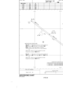
CYTE - Kinngait Airport
Located in Cape Dorset, Canada
ICAO - CYTE, IATA - YTE
Data provided by AirmateGeneral information
Coordinates: N64°13'49" W76°31'30"
Elevation is 158 feet MSL.
Magnetic variation is -22.2911° East View others Airports in Nunavut
Operational data
Special qualification required
Current time UTC:
Current local time:
Weather
METAR: CYTE 022333Z AUTO 25003KT 6SM HZ SCT022 OVC030 M20/M23 A3022 RMK SLP244
TAF: TAF AMD CYTE 022027Z 0220/0307 27005KT 5SM -SN BKN020 TEMPO 0220/0303 P6SM NSW SCT020 BECMG 0220/0222 26007KT FM030300 28005KT P6SM SCT020 TEMPO 0303/0307 5SM -SN BKN020 RMK NXT FCST BY 030100Z
Communications frequencies: [VIEW]
Runways:
| RWY identifier | QFU | Length (ft) | Width (ft) | Surface | LDA (ft) |
| 13 | 127° | 3988 | 100 | GRAVE | 3988 |
| 31 | 307° | 3988 | 100 | GRAVE | 3988 |
Airport contact information
Address: Cape Dorset Canada
Satellite view of CYTE
Sorry, we have no imagery here.
Sorry, we have no imagery here.
Sorry, we have no imagery here.
Sorry, we have no imagery here.
Sorry, we have no imagery here.
Sorry, we have no imagery here.


