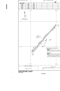
ADC chart of CYST
 Satellite view of CYST
Satellite view of CYST
Sorry, we have no imagery here.
Sorry, we have no imagery here.
Sorry, we have no imagery here.
Sorry, we have no imagery here.
Sorry, we have no imagery here.
Sorry, we have no imagery here.


CYST - St. Theresa Point
Located in St. Theresa Point, Canada
ICAO - CYST, IATA - YST
Data provided by AirmateGeneral information
Coordinates: N53°50'44" W94°51'8"
Elevation is 767 feet MSL.
Magnetic variation is 0.1983° East View others Airports in Manitoba
Operational data
Special qualification required
Current time UTC:
Current local time:
Weather at : CYIV - Island Lake ( 13 km )
METAR: CYIV 091900Z AUTO 12009KT 9SM CLR 03/M13 A2998 RMK SLP168
TAF: TAF CYIV 091840Z 0919/1007 12010KT P6SM SKC BECMG 1002/1004 VRB03KT RMK FCST BASED ON AUTO OBS. NXT FCST BY 100100Z
Communications frequencies: [VIEW]
Runways:
| RWY identifier | QFU | Length (ft) | Width (ft) | Surface | LDA (ft) |
| 04 | 41° | 3391 | 75 | GRAVE | 3391 |
| 22 | 221° | 3391 | 75 | GRAVE | 3391 |
Airport contact information
Address: St. Theresa Point Canada
Satellite view of CYST
Sorry, we have no imagery here.
Sorry, we have no imagery here.
Sorry, we have no imagery here.
Sorry, we have no imagery here.
Sorry, we have no imagery here.
Sorry, we have no imagery here.