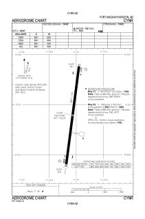
ADC chart of CYNR
 Satellite view of CYNR
Satellite view of CYNR
Sorry, we have no imagery here.
Sorry, we have no imagery here.
Sorry, we have no imagery here.
Sorry, we have no imagery here.
Sorry, we have no imagery here.
Sorry, we have no imagery here.


CYNR - Horizon
Located in Fort Mackay, Canada
ICAO - CYNR, IATA - HZP
Data provided by AirmateGeneral information
Coordinates: N57°22'54" W111°42'4"
Elevation is 916 feet MSL.
Magnetic variation is 14.91° East View others Airports in Alberta
Operational data
Special qualification required
Current time UTC:
Current local time:
Weather at : - ( 0 km )
METAR: YBTL 051106Z AUTO 20009KT 9999 TSRA FEW036 SCT052 OVC099 24/23 Q1014
Communications frequencies: [VIEW]
Runways:
| RWY identifier | QFU | Length (ft) | Width (ft) | Surface | LDA (ft) |
| 17 | 187° | 6001 | 150 | ASPH | 6001 |
| 35 | 7° | 6001 | 150 | ASPH | 6001 |
Airport contact information
Address: Fort Mackay Canada
Satellite view of CYNR
Sorry, we have no imagery here.
Sorry, we have no imagery here.
Sorry, we have no imagery here.
Sorry, we have no imagery here.
Sorry, we have no imagery here.
Sorry, we have no imagery here.