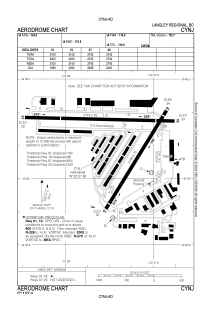
ADC chart of CYNJ
 Satellite view of CYNJ
Satellite view of CYNJ
Sorry, we have no imagery here.
Sorry, we have no imagery here.
Sorry, we have no imagery here.
Sorry, we have no imagery here.
Sorry, we have no imagery here.


CYNJ - Langley Regional
Located in , Canada
ICAO - CYNJ, IATA - YLY
Data provided by AirmateGeneral information
Coordinates: N49°6'3" W122°37'51"
Elevation is 34 feet MSL.
Magnetic variation is 16.83° East View others Airports in British Columbia
Operational data
Special qualification required
Current time UTC:
Current local time:
Communications frequencies: [VIEW]
Runways:
| RWY identifier | QFU | Length (ft) | Width (ft) | Surface | LDA (ft) |
| 01 | 32° | 2100 | 75 | ASPH | 1996 |
| 19 | 212° | 2100 | 75 | ASPH | 2004 |
| 07 | 91° | 2743 | 75 | ASPH | 2089 |
| 25 | 271° | 2743 | 75 | ASPH | 2400 |
Airport contact information
Address: Canada
Other aviation service providers
Flight schools

Langley Flying School Inc.
Langley Flying School Inc.
administration@langleyflyingschool.com+16045326461
Satellite view of CYNJ
Sorry, we have no imagery here.
Sorry, we have no imagery here.
Sorry, we have no imagery here.
Sorry, we have no imagery here.
Sorry, we have no imagery here.