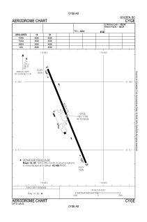
ADC chart of CYGE
 Satellite view of CYGE
Satellite view of CYGE
Sorry, we have no imagery here.
Sorry, we have no imagery here.
Sorry, we have no imagery here.
Sorry, we have no imagery here.
Sorry, we have no imagery here.
Sorry, we have no imagery here.


CYGE - Golden
Located in , Canada
ICAO - CYGE, IATA -
Data provided by AirmateGeneral information
Coordinates: N51°17'57" W116°58'56"
Elevation is 2576 feet MSL.
Magnetic variation is 15.9219° East View others Airports in British Columbia
Operational data
Special qualification required
Current time UTC:
Current local time:
Weather
METAR: CYGE 061900Z 17007KT 120V200 20SM BKN230 13/M05 A3014 RMK CC6 SLP226
Communications frequencies: [VIEW]
Runways:
| RWY identifier | QFU | Length (ft) | Width (ft) | Surface | LDA (ft) |
| 14 | 158° | 4528 | 75 | ASPH | 4528 |
| 32 | 338° | 4528 | 75 | ASPH | 4528 |
Airport contact information
Address: Canada
Satellite view of CYGE
Sorry, we have no imagery here.
Sorry, we have no imagery here.
Sorry, we have no imagery here.
Sorry, we have no imagery here.
Sorry, we have no imagery here.
Sorry, we have no imagery here.