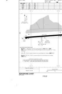
ADC chart of CYDQ
 Satellite view of CYDQ
Satellite view of CYDQ
Sorry, we have no imagery here.
Sorry, we have no imagery here.
Sorry, we have no imagery here.
Sorry, we have no imagery here.
Sorry, we have no imagery here.
Sorry, we have no imagery here.


CYDQ - Dawson Creek
Located in , Canada
ICAO - CYDQ, IATA - YDQ
Data provided by AirmateGeneral information
Coordinates: N55°44'30" W120°11'0"
Elevation is 2147 feet MSL.
Magnetic variation is 18.2411° East View others Airports in British Columbia
Operational data
Special qualification required
Current time UTC:
Current local time:
Weather
TAF: TAF CYDQ 070040Z 0701/0705 24010KT P6SM BKN240 BECMG 0701/0703 VRB03KT RMK FCST BASED ON AUTO OBS. NXT FCST BY 071300Z
Communications frequencies: [VIEW]
Runways:
| RWY identifier | QFU | Length (ft) | Width (ft) | Surface | LDA (ft) |
| 07 | 86° | 5001 | 150 | ASPH | 5001 |
| 25 | 266° | 5001 | 150 | ASPH | 5001 |
Airport contact information
Address: Canada
Satellite view of CYDQ
Sorry, we have no imagery here.
Sorry, we have no imagery here.
Sorry, we have no imagery here.
Sorry, we have no imagery here.
Sorry, we have no imagery here.
Sorry, we have no imagery here.