ADC chart of CN37
 Satellite view of CN37
Satellite view of CN37
Sorry, we have no imagery here.
Sorry, we have no imagery here.
Sorry, we have no imagery here.
Sorry, we have no imagery here.
Sorry, we have no imagery here.
Sorry, we have no imagery here.


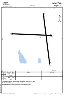
CN37 - Kelso Valley
Located in Mojave, United States
ICAO - CN37, IATA -
Data provided by AirmateGeneral information
Coordinates: N35°23'1" W118°13'13"
Elevation is 4074 feet MSL.
Magnetic variation is 14° East View others Airports in California
Operational data
Special qualification required
Current time UTC:
Current local time:
Weather at : KTSP - Tehachapi Muni ( 34 km )
METAR: KTSP 050515Z AUTO 30004KT 10SM CLR 05/M00 A3026 RMK AO2
Communications frequencies: [VIEW]
Runways:
| RWY identifier | QFU | Length (ft) | Width (ft) | Surface | LDA (ft) |
| 08 | 0° | 2673 | 100 | EARTH | |
| 26 | 0° | 2673 | 100 | EARTH | |
| 16 | 0° | 3436 | 100 | EARTH | |
| 34 | 0° | 3436 | 100 | EARTH |
Airport contact information
Address: Mojave United States
Satellite view of CN37
Sorry, we have no imagery here.
Sorry, we have no imagery here.
Sorry, we have no imagery here.
Sorry, we have no imagery here.
Sorry, we have no imagery here.
Sorry, we have no imagery here.