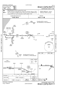
IAC chart of C91
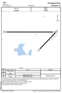
 ADC chart of C91
 Satellite view of C91

ADC chart of C91
Satellite view of C91
Sorry, we have no imagery here.
Sorry, we have no imagery here.
Sorry, we have no imagery here.
Sorry, we have no imagery here.
Sorry, we have no imagery here.
Sorry, we have no imagery here.


C91 - Dowagiac Muni
Located in Dowagiac, United States
ICAO - C91, IATA -
Data provided by AirmateGeneral information
Coordinates: N41°59'35" W86°7'42"
Elevation is 747 feet MSL.
Magnetic variation is -05° East View others Airports in Michigan
Operational data
Special qualification required
Current time UTC:
Current local time:
Weather at : KBEH - Southwest Michigan Rgnl ( 29 km )
METAR: KBEH 022006Z AUTO 12016G23KT 10SM FEW034 BKN050 OVC060 08/07 A2957 RMK AO2 LTG DSNT N AND NE T00830072
Communications frequencies: [VIEW]
Runways:
| RWY identifier | QFU | Length (ft) | Width (ft) | Surface | LDA (ft) |
| 04 | 44° | 2176 | 100 | GRASS | |
| 22 | 224° | 2176 | 100 | GRASS | |
| 09 | 90° | 4700 | 100 | ASPH | |
| 27 | 270° | 4700 | 100 | ASPH |
Airport contact information
Address: Dowagiac United States
Satellite view of C91
Sorry, we have no imagery here.
Sorry, we have no imagery here.
Sorry, we have no imagery here.
Sorry, we have no imagery here.
Sorry, we have no imagery here.
Sorry, we have no imagery here.