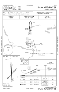
IAC chart of C47
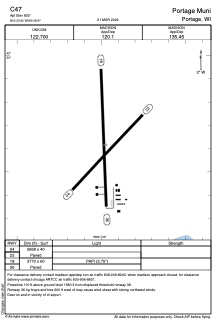
 ADC chart of C47
 Satellite view of C47
ADC chart of C47
Satellite view of C47
Sorry, we have no imagery here.
Sorry, we have no imagery here.
Sorry, we have no imagery here.
Sorry, we have no imagery here.
Sorry, we have no imagery here.
Sorry, we have no imagery here.


C47 - Portage Muni
Located in Portage, United States
ICAO - C47, IATA -
Data provided by AirmateGeneral information
Coordinates: N43°33'37" W89°28'58"
Elevation is 825 feet MSL.
Magnetic variation is -03° East View others Airports in Wisconsin
Operational data
Special qualification required
Current time UTC:
Current local time:
Weather at : KDLL - Baraboo/Wisconsin Dells Rgnl ( 24 km )
METAR: KDLL 240655Z AUTO 00000KT 10SM CLR 05/01 A3016 RMK AO2 T00470012
Communications frequencies: [VIEW]
Runways:
| RWY identifier | QFU | Length (ft) | Width (ft) | Surface | LDA (ft) |
| 04 | 43° | 2668 | 40 | ASPH | |
| 22 | 223° | 2668 | 40 | ASPH | |
| 18 | 178° | 3770 | 60 | ASPH | |
| 36 | 358° | 3770 | 60 | ASPH |
Airport contact information
Address: Portage United States
Satellite view of C47
Sorry, we have no imagery here.
Sorry, we have no imagery here.
Sorry, we have no imagery here.
Sorry, we have no imagery here.
Sorry, we have no imagery here.
Sorry, we have no imagery here.