ADC chart of C27
 Satellite view of C27
Satellite view of C27
Sorry, we have no imagery here.
Sorry, we have no imagery here.
Sorry, we have no imagery here.
Sorry, we have no imagery here.
Sorry, we have no imagery here.
Sorry, we have no imagery here.


C27 - Manchester Muni
Located in Manchester, United States
ICAO - C27, IATA -
Data provided by AirmateGeneral information
Coordinates: N42°29'26" W91°29'52"
Elevation is 987 feet MSL.
Magnetic variation is 02° East View others Airports in Iowa
Operational data
Special qualification required
Current time UTC:
Current local time:
Weather at : KIIB - James H Connell Fld At Independence Muni ( 37 km )
METAR: KIIB 022015Z AUTO 23023G35KT 10SM SCT047 SCT055 SCT075 21/08 A2930 RMK AO2 T02140080
Communications frequencies: [VIEW]
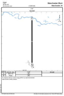
Runways:
| RWY identifier | QFU | Length (ft) | Width (ft) | Surface | LDA (ft) |
| 18 | 0° | 3465 | 50 | ASPH | |
| 36 | 0° | 3465 | 50 | ASPH |
Airport contact information
Address: Manchester United States
Satellite view of C27
Sorry, we have no imagery here.
Sorry, we have no imagery here.
Sorry, we have no imagery here.
Sorry, we have no imagery here.
Sorry, we have no imagery here.
Sorry, we have no imagery here.