ADC chart of C00
 Satellite view of C00
Satellite view of C00
Sorry, we have no imagery here.
Sorry, we have no imagery here.
Sorry, we have no imagery here.
Sorry, we have no imagery here.
Sorry, we have no imagery here.
Sorry, we have no imagery here.


C00 - Mercer County
Located in Aledo, United States
ICAO - C00, IATA -
Data provided by AirmateGeneral information
Coordinates: N41°14'55" W90°44'14"
Elevation is 740 feet MSL.
Magnetic variation is 02° East View others Airports in Illinois
Operational data
Special qualification required
Current time UTC:
Current local time:
Weather at : KMLI - Quad Cities Intl ( 29 km )
METAR: KMLI 070152Z 20004KT 10SM CLR 04/M02 A2999 RMK AO2 SLP161 T00441017
TAF: KMLI 062320Z 0700/0724 29009KT P6SM SCT250 FM071300 34012G22KT P6SM SCT080 SCT250 FM071600 35015G25KT P6SM SCT250
Communications frequencies: [VIEW]
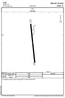
Runways:
| RWY identifier | QFU | Length (ft) | Width (ft) | Surface | LDA (ft) |
| 17 | 0° | 2480 | 45 | ASPH | |
| 35 | 0° | 2480 | 45 | ASPH |
Airport contact information
Address: Aledo United States
Satellite view of C00
Sorry, we have no imagery here.
Sorry, we have no imagery here.
Sorry, we have no imagery here.
Sorry, we have no imagery here.
Sorry, we have no imagery here.
Sorry, we have no imagery here.