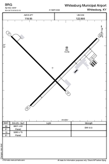
ADC chart of BRG
 Satellite view of BRG
Satellite view of BRG
Sorry, we have no imagery here.
Sorry, we have no imagery here.
Sorry, we have no imagery here.
Sorry, we have no imagery here.
Sorry, we have no imagery here.
Sorry, we have no imagery here.


BRG - Whitesburg Municipal Airport
Located in Whitesburg, United States
ICAO - BRG, IATA - BRG
Data provided by AirmateGeneral information
Coordinates: N34°38'45" W106°50'11"
Elevation is 5200 feet MSL.
Magnetic variation is 11° East View others Airports in Kentucky
Operational data
Special qualification required
Current time UTC:
Current local time:
Weather at : KBRG - Belen Rgnl ( 0 km )
METAR: KBRG 021155Z AUTO 18003KT 10SM CLR 01/M08 A2970 RMK AO2 T00091085 10045 21013
Communications frequencies: [VIEW]
Runways:
Airport contact information
Address: Whitesburg United States
Satellite view of BRG
Sorry, we have no imagery here.
Sorry, we have no imagery here.
Sorry, we have no imagery here.
Sorry, we have no imagery here.
Sorry, we have no imagery here.
Sorry, we have no imagery here.