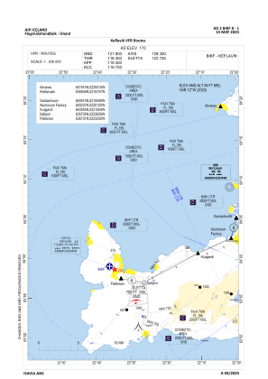
VAC chart of BIKF
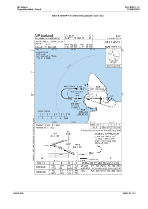
 IAC chart of BIKF
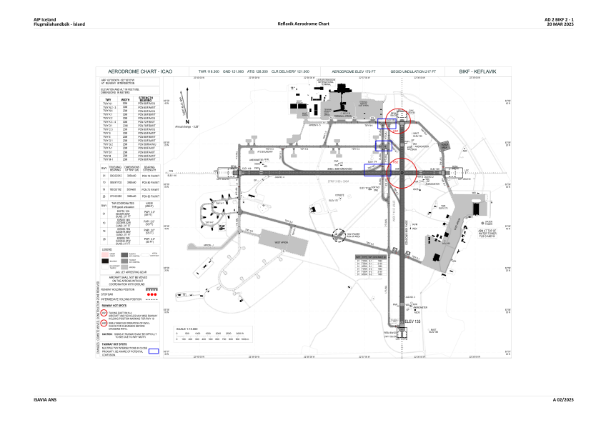
 ADC chart of BIKF
 Satellite view of BIKF
IAC chart of BIKFADC chart of BIKF
Satellite view of BIKF
Sorry, we have no imagery here.
Sorry, we have no imagery here.
Sorry, we have no imagery here.
Sorry, we have no imagery here.
Sorry, we have no imagery here.
Sorry, we have no imagery here.


BIKF - Keflavik
Located in Keflavik, Iceland
ICAO - BIKF, IATA - KEF
Data provided by AirmateGeneral information
Coordinates: N63°59'6" W22°36'20"
Elevation is 170 feet MSL.
View others Airports in Southern Peninsula
Operational data
Special qualification required
Current time UTC:
Current local time:
Weather
METAR: BIKF 301430Z 09028KT 1500 R10/1000N -SN OVC006 01/00 Q0991
Communications frequencies: [VIEW]
Runways:
| RWY identifier | QFU | Length (ft) | Width (ft) | Surface | LDA (ft) |
| 01 | 0° | 10020 | 197 | ASPH | |
| 19 | 180° | 10020 | 197 | ASPH | |
| 10 | 90° | 10056 | 197 | ASPH | |
| 28 | 270° | 10056 | 197 | ASPH |
Airport contact information
Address: Keflavik Iceland
Satellite view of BIKF
Sorry, we have no imagery here.
Sorry, we have no imagery here.
Sorry, we have no imagery here.
Sorry, we have no imagery here.
Sorry, we have no imagery here.
Sorry, we have no imagery here.