ADC chart of A32
 Satellite view of A32
Satellite view of A32
Sorry, we have no imagery here.
Sorry, we have no imagery here.
Sorry, we have no imagery here.
Sorry, we have no imagery here.
Sorry, we have no imagery here.
Sorry, we have no imagery here.


A32 - Butte Valley
Located in Dorris, United States
ICAO - A32, IATA -
Data provided by AirmateGeneral information
Coordinates: N41°53'14" W121°58'32"
Elevation is 4243 feet MSL.
Magnetic variation is 18° East View others Airports in California
Operational data
Special qualification required
Current time UTC:
Current local time:
Weather at : KLMT - Crater Lake/Klamath Rgnl ( 36 km )
METAR: KLMT 050953Z AUTO 00000KT 10SM CLR M01/M04 A3033 RMK AO2 SLP272 T10111039
Communications frequencies: [VIEW]
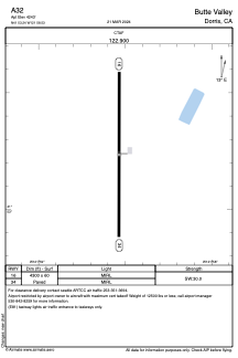
Runways:
| RWY identifier | QFU | Length (ft) | Width (ft) | Surface | LDA (ft) |
| 16 | 179° | 4300 | 60 | ASPH | |
| 34 | 359° | 4300 | 60 | ASPH |
Airport contact information
Address: Dorris United States
Satellite view of A32
Sorry, we have no imagery here.
Sorry, we have no imagery here.
Sorry, we have no imagery here.
Sorry, we have no imagery here.
Sorry, we have no imagery here.
Sorry, we have no imagery here.