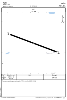
ADC chart of A26
 Satellite view of A26
Satellite view of A26
Sorry, we have no imagery here.
Sorry, we have no imagery here.
Sorry, we have no imagery here.
Sorry, we have no imagery here.
Sorry, we have no imagery here.
Sorry, we have no imagery here.


A26 - Adin
Located in Adin, United States
ICAO - A26, IATA -
Data provided by AirmateGeneral information
Coordinates: N41°11'11" W120°57'16"
Elevation is 4234 feet MSL.
Magnetic variation is 17° East View others Airports in California
Operational data
Special qualification required
Current time UTC:
Current local time:
Weather at : KAAT - Alturas Muni ( 46 km )
METAR: KAAT 051355Z AUTO 06003KT 10SM CLR M05/M07 A3038 RMK AO2 SLP298 T10501067 $
Communications frequencies: [VIEW]
Runways:
| RWY identifier | QFU | Length (ft) | Width (ft) | Surface | LDA (ft) |
| 09 | 0° | 2850 | 40 | ASPH | |
| 27 | 0° | 2850 | 40 | ASPH |
Airport contact information
Address: Adin United States
Satellite view of A26
Sorry, we have no imagery here.
Sorry, we have no imagery here.
Sorry, we have no imagery here.
Sorry, we have no imagery here.
Sorry, we have no imagery here.
Sorry, we have no imagery here.