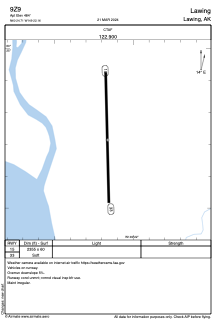
ADC chart of 9Z9
 Satellite view of 9Z9
Satellite view of 9Z9
Sorry, we have no imagery here.
Sorry, we have no imagery here.
Sorry, we have no imagery here.
Sorry, we have no imagery here.
Sorry, we have no imagery here.
Sorry, we have no imagery here.


9Z9 - Lawing
Located in Lawing,
ICAO - 9Z9, IATA -
Data provided by AirmateGeneral information
Coordinates: N60°24'43" W149°22'10"
Elevation is 484 feet MSL.
Magnetic variation is 25° East View others Airports in Alaska
Operational data
Special qualification required
Current time UTC:
Current local time:
Weather at : PAWD - Seward ( 31 km )
METAR: PAWD 110653Z AUTO 20006KT 10SM CLR 12/08 A3004 RMK AO2 SLP173 T01170078 TSNO
Communications frequencies: [VIEW]
Runways:
| RWY identifier | QFU | Length (ft) | Width (ft) | Surface | LDA (ft) |
| 15 | 178° | 2355 | 60 | GRAVEL | |
| 33 | 358° | 2355 | 60 | GRAVEL |
Airport contact information
Address: Lawing