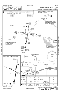
IAC chart of 9K8
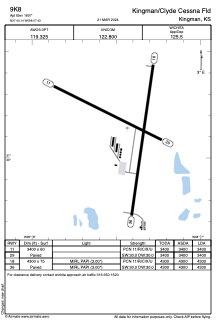
 ADC chart of 9K8
 Satellite view of 9K8
ADC chart of 9K8
Satellite view of 9K8
Sorry, we have no imagery here.
Sorry, we have no imagery here.
Sorry, we have no imagery here.
Sorry, we have no imagery here.
Sorry, we have no imagery here.
Sorry, we have no imagery here.


9K8 - Kingman/Clyde Cessna Fld
Located in Kingman, United States
ICAO - 9K8, IATA -
Data provided by AirmateGeneral information
Coordinates: N37°40'8" W98°7'26"
Elevation is 1607 feet MSL.
Magnetic variation is 06° East View others Airports in Kansas
Operational data
Special qualification required
Current time UTC:
Current local time:
Weather at : KHUT - Hutchinson Rgnl ( 50 km )
METAR: KHUT 101752Z 33016G26KT 10SM CLR 22/M02 A3027 RMK AO2 PK WND 36030/1733 SLP237 T02221022 10222 20044 50003
TAF: KHUT 101731Z 1018/1118 34018G27KT P6SM SKC FM110000 34012KT P6SM SKC FM110300 35005KT P6SM SKC
Communications frequencies: [VIEW]
Runways:
| RWY identifier | QFU | Length (ft) | Width (ft) | Surface | LDA (ft) |
| 11 | 116° | 3400 | 60 | CONC | 3400 |
| 29 | 296° | 3400 | 60 | CONC | 3400 |
| 18 | 188° | 4300 | 75 | CONC | 4300 |
| 36 | 8° | 4300 | 75 | CONC | 4300 |
Airport contact information
Address: Kingman United States
Other aviation service providers
Flight schools

Satellite view of 9K8
Sorry, we have no imagery here.
Sorry, we have no imagery here.
Sorry, we have no imagery here.
Sorry, we have no imagery here.
Sorry, we have no imagery here.
Sorry, we have no imagery here.