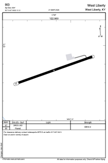
ADC chart of 9I3
 Satellite view of 9I3
Satellite view of 9I3
Sorry, we have no imagery here.
Sorry, we have no imagery here.
Sorry, we have no imagery here.
Sorry, we have no imagery here.
Sorry, we have no imagery here.
Sorry, we have no imagery here.


9I3 - West Liberty
Located in West Liberty, United States
ICAO - 9I3, IATA -
Data provided by AirmateGeneral information
Coordinates: N37°54'52" W83°15'7"
Elevation is 934 feet MSL.
Magnetic variation is -04° East View others Airports in Kentucky
Operational data
Special qualification required
Current time UTC:
Current local time:
Weather at : KJKL - Julian Carroll ( 36 km )
METAR: KJKL 012153Z AUTO 00000KT 10SM CLR 13/02 A3007 RMK AO2 SLP182 T01280017
TAF: KJKL 011730Z 0118/0218 VRB03KT P6SM SCT250 FM020900 16005KT P6SM BKN250 WS020/20045KT FM021400 18008G22KT P6SM FEW100 SCT250
Communications frequencies: [VIEW]
Runways:
| RWY identifier | QFU | Length (ft) | Width (ft) | Surface | LDA (ft) |
| 07 | 71° | 2400 | 60 | ASPH | |
| 25 | 251° | 2400 | 60 | ASPH |
Airport contact information
Address: West Liberty United States
Satellite view of 9I3
Sorry, we have no imagery here.
Sorry, we have no imagery here.
Sorry, we have no imagery here.
Sorry, we have no imagery here.
Sorry, we have no imagery here.
Sorry, we have no imagery here.