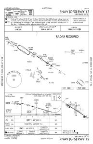
IAC chart of 9D9
 Satellite view of 9D9
Satellite view of 9D9
Sorry, we have no imagery here.
Sorry, we have no imagery here.
Sorry, we have no imagery here.
Sorry, we have no imagery here.
Sorry, we have no imagery here.
Sorry, we have no imagery here.


9D9 - Hastings
Located in Hastings, United States
ICAO - 9D9, IATA -
Data provided by AirmateGeneral information
Coordinates: N42°39'48" W85°20'45"
Elevation is 800 feet MSL.
Magnetic variation is -06° East View others Airports in Michigan
Operational data
Special qualification required
Current time UTC:
Current local time:
Weather at : KGRR - Gerald R Ford Intl ( 28 km )
METAR: KGRR 021953Z 13014G22KT 10SM OVC007 05/04 A2967 RMK AO2 PK WND 11026/1914 LTG DSNT SW AND W RAE07 SLP053 P0000 T00500039 $
TAF: KGRR 021740Z 0218/0318 10013KT 3SM TSRA BR OVC008CB WS020/16040KT FM022100 14012G22KT 4SM SHRA BR OVC007 WS020/19045KT FM030000 19013G27KT 5SM SHRA BR VCTS OVC013CB WS020/20050KT FM030200 21014G27KT 6SM SHRA BR VCTS BKN040CB WS020/22045KT FM030400 22014G26KT P6SM VCTS BKN028CB FM030800 24012G21KT P6SM SCT080
Communications frequencies: [VIEW]
Runways:
| RWY identifier | QFU | Length (ft) | Width (ft) | Surface | LDA (ft) |
| 09 | 87° | 2380 | 170 | GRASS | |
| 27 | 267° | 2380 | 170 | GRASS | |
| 12 | 122° | 5003 | 75 | ASPH | |
| 30 | 302° | 5003 | 75 | ASPH | |
| 18 | 179° | 1952 | 200 | GRASS | |
| 36 | 359° | 1952 | 200 | GRASS |
Airport contact information
Address: Hastings United States
Satellite view of 9D9
Sorry, we have no imagery here.
Sorry, we have no imagery here.
Sorry, we have no imagery here.
Sorry, we have no imagery here.
Sorry, we have no imagery here.
Sorry, we have no imagery here.