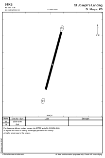
ADC chart of 91KS
 Satellite view of 91KS
Satellite view of 91KS
Sorry, we have no imagery here.
Sorry, we have no imagery here.
Sorry, we have no imagery here.
Sorry, we have no imagery here.
Sorry, we have no imagery here.
Sorry, we have no imagery here.


91KS - St Joseph's Landing
Located in St. Mary's, United States
ICAO - 91KS, IATA -
Data provided by AirmateGeneral information
Coordinates: N39°14'32" W96°1'59"
Elevation is 1158 feet MSL.
View others Airports in Kansas
Operational data
Special qualification required
Current time UTC:
Current local time:
Weather at : KTOP - Philip Billard Muni ( 40 km )
METAR: KTOP 101053Z AUTO 28006KT 10SM CLR 09/03 A3009 RMK AO2 SLP187 T00940028
TAF: KTOP 101120Z 1012/1112 28006KT P6SM SCT150 FM101400 33012G22KT P6SM FEW150 FM101700 34017G27KT P6SM FEW150 FM110100 32006KT P6SM FEW250
Communications frequencies: [VIEW]
Runways:
| RWY identifier | QFU | Length (ft) | Width (ft) | Surface | LDA (ft) |
| 01 | 15° | 2500 | 80 | GRASS | |
| 19 | 195° | 2500 | 80 | GRASS |
Airport contact information
Address: St. Mary's United States
Satellite view of 91KS
Sorry, we have no imagery here.
Sorry, we have no imagery here.
Sorry, we have no imagery here.
Sorry, we have no imagery here.
Sorry, we have no imagery here.
Sorry, we have no imagery here.