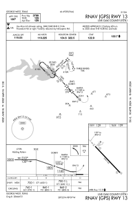
IAC chart of 8T6
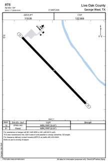
 ADC chart of 8T6
 Satellite view of 8T6
ADC chart of 8T6
Satellite view of 8T6
Sorry, we have no imagery here.
Sorry, we have no imagery here.
Sorry, we have no imagery here.
Sorry, we have no imagery here.
Sorry, we have no imagery here.
Sorry, we have no imagery here.


8T6 - Live Oak County
Located in George West, United States
ICAO - 8T6, IATA -
Data provided by AirmateGeneral information
Coordinates: N28°21'46" W98°6'59"
Elevation is 129 feet MSL.
Magnetic variation is 07° East View others Airports in Texas
Operational data
Special qualification required
Current time UTC:
Current local time:
Weather at : KBEA - Beeville Muni ( 32 km )
METAR: KBEA 020535Z AUTO 15016G21KT 10SM OVC008 23/21 A2958 RMK AO2 T02260210
Communications frequencies: [VIEW]
Runways:
| RWY identifier | QFU | Length (ft) | Width (ft) | Surface | LDA (ft) |
| 13 | 136° | 3799 | 60 | ASPH | |
| 31 | 316° | 3799 | 60 | ASPH |
Airport contact information
Address: George West United States
Satellite view of 8T6
Sorry, we have no imagery here.
Sorry, we have no imagery here.
Sorry, we have no imagery here.
Sorry, we have no imagery here.
Sorry, we have no imagery here.
Sorry, we have no imagery here.