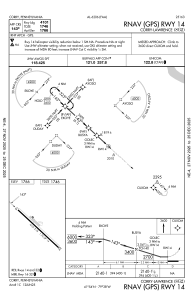
IAC chart of 8G2
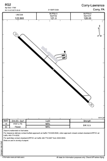
 ADC chart of 8G2
 Satellite view of 8G2
ADC chart of 8G2
Satellite view of 8G2
Sorry, we have no imagery here.
Sorry, we have no imagery here.
Sorry, we have no imagery here.
Sorry, we have no imagery here.
Sorry, we have no imagery here.
Sorry, we have no imagery here.


8G2 - Corry-Lawrence
Located in Corry, United States
ICAO - 8G2, IATA -
Data provided by AirmateGeneral information
Coordinates: N41°54'27" W79°38'28"
Elevation is 1766 feet MSL.
Magnetic variation is -10° East View others Airports in Pennsylvania
Operational data
Special qualification required
Current time UTC:
Current local time:
Weather at : KJHW - Chautauqua County/Jamestown ( 42 km )
METAR: KJHW 071756Z AUTO 24008KT 220V280 10SM FEW038 06/M03 A2968 RMK AO2 SLP069 T00611028 10061 20000 56023
TAF: KJHW 071728Z 0718/0818 23008KT P6SM SCT250 FM072200 27013G24KT P6SM BKN045 PROB30 0722/0723 4SM -SHRA OVC025 FM072300 29014G25KT 2SM -SHSN OVC025 FM080100 30016G26KT P6SM OVC015 PROB30 0801/0802 4SM -SHSN OVC008 FM080300 31016G26KT P6SM BKN020 PROB30 0806/0812 4SM -SHSN OVC015
Communications frequencies: [VIEW]
Runways:
| RWY identifier | QFU | Length (ft) | Width (ft) | Surface | LDA (ft) |
| 14 | 133° | 4101 | 75 | ASPH | |
| 32 | 313° | 4101 | 75 | ASPH |
Airport contact information
Address: Corry United States
Satellite view of 8G2
Sorry, we have no imagery here.
Sorry, we have no imagery here.
Sorry, we have no imagery here.
Sorry, we have no imagery here.
Sorry, we have no imagery here.
Sorry, we have no imagery here.