ADC chart of 89TS
 Satellite view of 89TS
Satellite view of 89TS
Sorry, we have no imagery here.
Sorry, we have no imagery here.
Sorry, we have no imagery here.
Sorry, we have no imagery here.
Sorry, we have no imagery here.
Sorry, we have no imagery here.


89TS - Carter Ranch
Located in Oakwood, United States
ICAO - 89TS, IATA -
Data provided by AirmateGeneral information
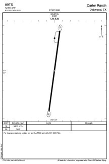
Coordinates: N31°34'1" W95°46'0"
Elevation is 215 feet MSL.
Magnetic variation is 04° East View others Airports in Texas
Operational data
Special qualification required
Current time UTC:
Current local time:
Weather at : KPSN - Palestine Muni ( 24 km )
METAR: KPSN 012215Z AUTO 15007G13KT 4SM BR OVC014 24/21 A2962 RMK AO2
Communications frequencies: [VIEW]
Runways:
| RWY identifier | QFU | Length (ft) | Width (ft) | Surface | LDA (ft) |
| 18 | 0° | 5200 | 75 | OTHER | |
| 36 | 0° | 5200 | 75 | OTHER |
Airport contact information
Address: Oakwood United States
Satellite view of 89TS
Sorry, we have no imagery here.
Sorry, we have no imagery here.
Sorry, we have no imagery here.
Sorry, we have no imagery here.
Sorry, we have no imagery here.
Sorry, we have no imagery here.