ADC chart of 89D
 Satellite view of 89D
Satellite view of 89D
Sorry, we have no imagery here.
Sorry, we have no imagery here.
Sorry, we have no imagery here.
Sorry, we have no imagery here.
Sorry, we have no imagery here.
Sorry, we have no imagery here.


89D - Kelleys Island Land Fld
Located in Kelleys Island, United States
ICAO - 89D, IATA -
Data provided by AirmateGeneral information
Coordinates: N41°36'11" W82°41'6"
Elevation is 598 feet MSL.
Magnetic variation is -07° East View others Airports in Ohio
Operational data
Special qualification required
Current time UTC:
Current local time:
Weather at : KPCW - Erie-Ottawa Intl ( 18 km )
METAR: KPCW 081335Z AUTO 33009G19KT 10SM OVC034 M02/M09 A3010 RMK AO2
Communications frequencies: [VIEW]
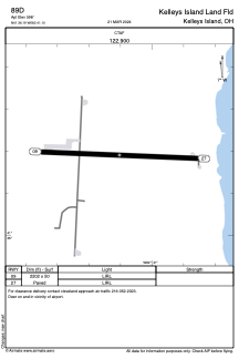
Runways:
| RWY identifier | QFU | Length (ft) | Width (ft) | Surface | LDA (ft) |
| 09 | 92° | 2202 | 50 | ASPH | |
| 27 | 272° | 2202 | 50 | ASPH |
Airport contact information
Address: Kelleys Island United States
Satellite view of 89D
Sorry, we have no imagery here.
Sorry, we have no imagery here.
Sorry, we have no imagery here.
Sorry, we have no imagery here.
Sorry, we have no imagery here.
Sorry, we have no imagery here.