ADC chart of 88D
 Satellite view of 88D
Satellite view of 88D
Sorry, we have no imagery here.
Sorry, we have no imagery here.
Sorry, we have no imagery here.
Sorry, we have no imagery here.
Sorry, we have no imagery here.
Sorry, we have no imagery here.


88D - Hinde
Located in Huron, United States
ICAO - 88D, IATA -
Data provided by AirmateGeneral information
Coordinates: N41°24'16" W82°36'11"
Elevation is 609 feet MSL.
Magnetic variation is -06° East View others Airports in Ohio
Operational data
Special qualification required
Current time UTC:
Current local time:
Weather at : KPCW - Erie-Ottawa Intl ( 25 km )
METAR: KPCW 081225Z AUTO 36013G21KT 10SM BKN036 BKN043 M03/M10 A3007 RMK AO2
Communications frequencies: [VIEW]
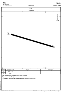
Runways:
| RWY identifier | QFU | Length (ft) | Width (ft) | Surface | LDA (ft) |
| 11 | 106° | 2501 | 70 | GRASS | |
| 29 | 286° | 2501 | 70 | GRASS |
Airport contact information
Address: Huron United States
Satellite view of 88D
Sorry, we have no imagery here.
Sorry, we have no imagery here.
Sorry, we have no imagery here.
Sorry, we have no imagery here.
Sorry, we have no imagery here.
Sorry, we have no imagery here.