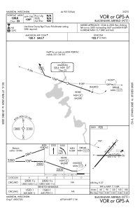
IAC chart of 87Y
 Satellite view of 87Y
Satellite view of 87Y
Sorry, we have no imagery here.
Sorry, we have no imagery here.
Sorry, we have no imagery here.
Sorry, we have no imagery here.
Sorry, we have no imagery here.
Sorry, we have no imagery here.


87Y - Blackhawk Airfield
Located in Madison, United States
ICAO - 87Y, IATA -
Data provided by AirmateGeneral information
Coordinates: N43°6'17" W89°11'7"
Elevation is 920 feet MSL.
Magnetic variation is -03° East View others Airports in Wisconsin
Operational data
Special qualification required
Current time UTC:
Current local time:
Weather at : KMSN - Dane County Rgnl/Truax Fld ( 13 km )
METAR: KMSN 290635Z AUTO 00000KT 3/4SM R36/P6000FT BR VV003 09/09 A3007 RMK AO2 T00940094
TAF: KMSN 290632Z 2907/3006 VRB03KT 1SM BR FEW015 TEMPO 2907/2911 5SM BR FM291100 VRB04KT P6SM BKN035 FM291600 31006KT P6SM SCT050 PROB30 2919/2922 -SHRA BKN050 FM292300 33005KT P6SM SCT090 FM300200 VRB03KT P6SM SCT110
Communications frequencies: [VIEW]
Runways:
| RWY identifier | QFU | Length (ft) | Width (ft) | Surface | LDA (ft) |
| 04 | 40° | 2814 | 57 | ASPH | |
| 22 | 220° | 2814 | 57 | ASPH | |
| 09 | 89° | 2203 | 56 | ASPH | |
| 27 | 270° | 2203 | 56 | ASPH |
Airport contact information
Address: Madison United States
Satellite view of 87Y
Sorry, we have no imagery here.
Sorry, we have no imagery here.
Sorry, we have no imagery here.
Sorry, we have no imagery here.
Sorry, we have no imagery here.
Sorry, we have no imagery here.