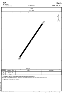
ADC chart of 83K
 Satellite view of 83K
Satellite view of 83K
Sorry, we have no imagery here.
Sorry, we have no imagery here.
Sorry, we have no imagery here.
Sorry, we have no imagery here.
Sorry, we have no imagery here.
Sorry, we have no imagery here.


83K - Harris
Located in Fort Ann, United States
ICAO - 83K, IATA -
Data provided by AirmateGeneral information
Coordinates: N43°24'35" W73°31'58"
Elevation is 261 feet MSL.
View others Airports in New York
Operational data
Special qualification required
Current time UTC:
Current local time:
Weather at : KGFL - Floyd Bennett Meml ( 10 km )
METAR: KGFL 071553Z AUTO 10004KT 10SM FEW055 BKN070 OVC085 04/M03 A2983 RMK AO2 SLP109 T00441028
TAF: KGFL 071129Z 0712/0812 VRB04KT P6SM VCSH SCT008 OVC050 TEMPO 0712/0716 5SM -SNRA BR BKN025 FM071600 15006KT P6SM VCSH OVC025 FM072100 18005KT P6SM SCT012 OVC020 PROB30 0721/0803 5SM -SNRA BR BKN015 FM080300 19004KT 4SM -SN BR SCT006 OVC015 FM080600 22005KT 2SM -SN BR BKN006 OVC012
Communications frequencies: [VIEW]
Runways:
| RWY identifier | QFU | Length (ft) | Width (ft) | Surface | LDA (ft) |
| 04 | 34° | 2200 | 50 | GRASS | |
| 22 | 214° | 2200 | 50 | GRASS |
Airport contact information
Address: Fort Ann United States
Satellite view of 83K
Sorry, we have no imagery here.
Sorry, we have no imagery here.
Sorry, we have no imagery here.
Sorry, we have no imagery here.
Sorry, we have no imagery here.
Sorry, we have no imagery here.