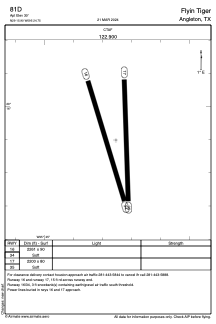
ADC chart of 81D
 Satellite view of 81D
Satellite view of 81D
Sorry, we have no imagery here.
Sorry, we have no imagery here.
Sorry, we have no imagery here.
Sorry, we have no imagery here.
Sorry, we have no imagery here.
Sorry, we have no imagery here.


81D - Flyin Tiger
Located in Angleton, United States
ICAO - 81D, IATA -
Data provided by AirmateGeneral information
Coordinates: N29°15'54" W95°24'45"
Elevation is 30 feet MSL.
Magnetic variation is 06° East View others Airports in Texas
Operational data
Special qualification required
Current time UTC:
Current local time:
Weather at : KLBX - Texas Gulf Coast Rgnl ( 18 km )
TAF: KLBX 021120Z 0212/0312 17015G25KT P6SM BKN015 FM021600 18020G30KT P6SM BKN020 FM030300 16015G25KT P6SM BKN010 AMD NOT SKED
Communications frequencies: [VIEW]
Runways:
| RWY identifier | QFU | Length (ft) | Width (ft) | Surface | LDA (ft) |
| 16 | 163° | 2261 | 90 | GRASS | |
| 34 | 343° | 2261 | 90 | GRASS | |
| 17 | 178° | 2200 | 80 | GRASS | |
| 35 | 358° | 2200 | 80 | GRASS |
Airport contact information
Address: Angleton United States
Satellite view of 81D
Sorry, we have no imagery here.
Sorry, we have no imagery here.
Sorry, we have no imagery here.
Sorry, we have no imagery here.
Sorry, we have no imagery here.
Sorry, we have no imagery here.