ADC chart of 80V
 Satellite view of 80V
Satellite view of 80V
Sorry, we have no imagery here.
Sorry, we have no imagery here.
Sorry, we have no imagery here.
Sorry, we have no imagery here.
Sorry, we have no imagery here.
Sorry, we have no imagery here.


80V - Medicine Bow
Located in Medicine Bow, United States
ICAO - 80V, IATA -
Data provided by AirmateGeneral information
Coordinates: N41°53'2" W106°10'58"
Elevation is 6658 feet MSL.
Magnetic variation is 12° East View others Airports in Wyoming
Operational data
Special qualification required
Current time UTC:
Current local time:
Weather at : KSAA - Shively Fld ( 73 km )
METAR: KSAA 071515Z AUTO 12011KT 10SM CLR 06/M09 A3018 RMK AO2
Communications frequencies: [VIEW]
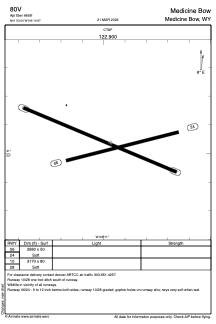
Runways:
| RWY identifier | QFU | Length (ft) | Width (ft) | Surface | LDA (ft) |
| 06 | 75° | 2680 | 50 | OTHER | |
| 24 | 255° | 2680 | 50 | OTHER | |
| 10 | 113° | 3170 | 80 | OTHER | |
| 28 | 293° | 3170 | 80 | OTHER |
Airport contact information
Address: Medicine Bow United States
Satellite view of 80V
Sorry, we have no imagery here.
Sorry, we have no imagery here.
Sorry, we have no imagery here.
Sorry, we have no imagery here.
Sorry, we have no imagery here.
Sorry, we have no imagery here.