ADC chart of 80G
 Satellite view of 80G
Satellite view of 80G
Sorry, we have no imagery here.
Sorry, we have no imagery here.
Sorry, we have no imagery here.
Sorry, we have no imagery here.
Sorry, we have no imagery here.
Sorry, we have no imagery here.


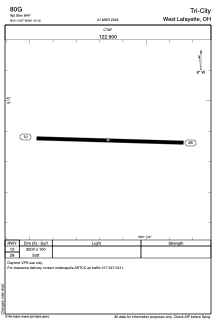
80G - Tri-City
Located in West Lafayette, United States
ICAO - 80G, IATA -
Data provided by AirmateGeneral information
Coordinates: N40°14'52" W81°44'10"
Elevation is 844 feet MSL.
Magnetic variation is -06° East View others Airports in Ohio
Operational data
Special qualification required
Current time UTC:
Current local time:
Weather at : KCDI - Cambridge Muni ( 33 km )
METAR: KCDI 131815Z AUTO 00000KT 10SM CLR 14/00 A3008 RMK AO2 T01440003
Communications frequencies: [VIEW]
Runways:
| RWY identifier | QFU | Length (ft) | Width (ft) | Surface | LDA (ft) |
| 10 | 92° | 3000 | 100 | GRASS | |
| 28 | 272° | 3000 | 100 | GRASS |
Airport contact information
Address: West Lafayette United States
Satellite view of 80G
Sorry, we have no imagery here.
Sorry, we have no imagery here.
Sorry, we have no imagery here.
Sorry, we have no imagery here.
Sorry, we have no imagery here.
Sorry, we have no imagery here.