ADC chart of 7S5
 Satellite view of 7S5
Satellite view of 7S5
Sorry, we have no imagery here.
Sorry, we have no imagery here.
Sorry, we have no imagery here.
Sorry, we have no imagery here.
Sorry, we have no imagery here.
Sorry, we have no imagery here.


7S5 - Independence State
Located in Independence, United States
ICAO - 7S5, IATA -
Data provided by AirmateGeneral information
Coordinates: N44°52'2" W123°11'54"
Elevation is 180 feet MSL.
Magnetic variation is 19° East View others Airports in Oregon
Operational data
Special qualification required
Current time UTC:
Current local time:
Weather at : KSLE - Mcnary Fld ( 16 km )
METAR: KSLE 141956Z 32003KT 10SM CLR 28/13 A3005 RMK AO2 SLP172 T02830133
TAF: KSLE 141722Z 1418/1518 34008KT P6SM SKC FM142100 34012G22KT P6SM SKC FM150600 33007KT P6SM SKC
Communications frequencies: [VIEW]
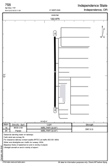
Runways:
| RWY identifier | QFU | Length (ft) | Width (ft) | Surface | LDA (ft) |
| 16 | 180° | 3002 | 60 | ASPH | |
| 34 | 360° | 3002 | 60 | ASPH |
Airport contact information
Address: Independence United States
Other aviation service providers
Flight schools

Satellite view of 7S5
Sorry, we have no imagery here.
Sorry, we have no imagery here.
Sorry, we have no imagery here.
Sorry, we have no imagery here.
Sorry, we have no imagery here.
Sorry, we have no imagery here.