ADC chart of 78OH
 Satellite view of 78OH
Satellite view of 78OH
Sorry, we have no imagery here.
Sorry, we have no imagery here.
Sorry, we have no imagery here.
Sorry, we have no imagery here.
Sorry, we have no imagery here.
Sorry, we have no imagery here.


78OH - Valley City Flying Club
Located in Valley City, United States
ICAO - 78OH, IATA -
Data provided by AirmateGeneral information
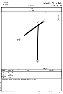
Coordinates: N41°15'27" W81°58'9"
Elevation is 867 feet MSL.
Magnetic variation is -06° East View others Airports in Ohio
Operational data
Special qualification required
Current time UTC:
Current local time:
Weather at : KCLE - Cleveland-Hopkins Intl ( 19 km )
METAR: KCLE 081851Z 33015G22KT 10SM SCT043 01/M09 A3009 RMK AO2 SLP215 T00061089
TAF: KCLE 081725Z 0818/0924 31012KT P6SM BKN035 FM082200 30008KT P6SM BKN060 PROB30 0900/0904 5SM -SHSN BKN035 FM090800 21004KT P6SM SCT060 FM092000 17006KT P6SM OVC060 PROB30 0921/0924 5SM -RA BKN025
Communications frequencies: [VIEW]
Runways:
| RWY identifier | QFU | Length (ft) | Width (ft) | Surface | LDA (ft) |
| 05 | 53° | 1800 | 50 | GRASS | |
| 23 | 233° | 1800 | 50 | GRASS | |
| 18 | 181° | 2300 | 100 | GRASS | |
| 36 | 1° | 2300 | 100 | GRASS |
Airport contact information
Address: Valley City United States
Satellite view of 78OH
Sorry, we have no imagery here.
Sorry, we have no imagery here.
Sorry, we have no imagery here.
Sorry, we have no imagery here.
Sorry, we have no imagery here.
Sorry, we have no imagery here.