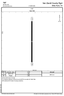
ADC chart of 76F
 Satellite view of 76F
Satellite view of 76F
Sorry, we have no imagery here.
Sorry, we have no imagery here.
Sorry, we have no imagery here.
Sorry, we have no imagery here.
Sorry, we have no imagery here.
Sorry, we have no imagery here.


76F - Van Zandt County Rgnl
Located in Wills Point, United States
ICAO - 76F, IATA -
Data provided by AirmateGeneral information
Coordinates: N32°40'53" W95°59'3"
Elevation is 522 feet MSL.
Magnetic variation is 06° East View others Airports in Texas
Operational data
Special qualification required
Current time UTC:
Current local time:
Weather at : KTRL - Terrell Muni ( 27 km )
METAR: KTRL 020118Z AUTO 16015G26KT 10SM FEW018 FEW025 OVC050 24/21 A2956 RMK AO2 PK WND 18026/0114 T02390206
Communications frequencies: [VIEW]
Runways:
| RWY identifier | QFU | Length (ft) | Width (ft) | Surface | LDA (ft) |
| 17 | 180° | 3230 | 50 | ASPH | |
| 35 | 360° | 3230 | 50 | ASPH |
Airport contact information
Address: Wills Point United States
Satellite view of 76F
Sorry, we have no imagery here.
Sorry, we have no imagery here.
Sorry, we have no imagery here.
Sorry, we have no imagery here.
Sorry, we have no imagery here.
Sorry, we have no imagery here.