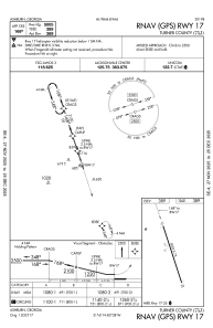
IAC chart of 75J
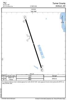
 ADC chart of 75J
 Satellite view of 75J
ADC chart of 75J
Satellite view of 75J
Sorry, we have no imagery here.
Sorry, we have no imagery here.
Sorry, we have no imagery here.
Sorry, we have no imagery here.
Sorry, we have no imagery here.
Sorry, we have no imagery here.


75J - Turner County
Located in Ashburn, United States
ICAO - 75J, IATA -
Data provided by AirmateGeneral information
Coordinates: N31°41'15" W83°37'59"
Elevation is 389 feet MSL.
Magnetic variation is -06° East View others Airports in Georgia
Operational data
Special qualification required
Current time UTC:
Current local time:
Weather at : KTMA - Henry Tift Myers ( 32 km )
METAR: KTMA 051055Z AUTO 00000KT 8SM CLR 18/18 A3020 RMK AO2 T01830183
Communications frequencies: [VIEW]
Runways:
| RWY identifier | QFU | Length (ft) | Width (ft) | Surface | LDA (ft) |
| 17 | 0° | 5005 | 75 | ASPH | |
| 35 | 0° | 5005 | 75 | ASPH |
Airport contact information
Address: Ashburn United States
Satellite view of 75J
Sorry, we have no imagery here.
Sorry, we have no imagery here.
Sorry, we have no imagery here.
Sorry, we have no imagery here.
Sorry, we have no imagery here.
Sorry, we have no imagery here.