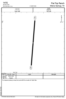
ADC chart of 74TE
 Satellite view of 74TE
Satellite view of 74TE
Sorry, we have no imagery here.
Sorry, we have no imagery here.
Sorry, we have no imagery here.
Sorry, we have no imagery here.
Sorry, we have no imagery here.
Sorry, we have no imagery here.


74TE - Flat Top Ranch
Located in Walnut Springs, United States
ICAO - 74TE, IATA -
Data provided by AirmateGeneral information
Coordinates: N32°3'41" W97°47'41"
Elevation is 960 feet MSL.
Magnetic variation is 05° East View others Airports in Texas
Operational data
Special qualification required
Current time UTC:
Current local time:
Weather at : KSEP - Stephenville Clark Rgnl ( 40 km )
METAR: KSEP 021115Z AUTO 18012G18KT 10SM OVC021 23/19 A2951 RMK AO2 T02280185
Communications frequencies: [VIEW]
Runways:
| RWY identifier | QFU | Length (ft) | Width (ft) | Surface | LDA (ft) |
| 18 | 0° | 4191 | 50 | ASPH | |
| 36 | 0° | 4191 | 50 | ASPH |
Airport contact information
Address: Walnut Springs United States
Satellite view of 74TE
Sorry, we have no imagery here.
Sorry, we have no imagery here.
Sorry, we have no imagery here.
Sorry, we have no imagery here.
Sorry, we have no imagery here.
Sorry, we have no imagery here.