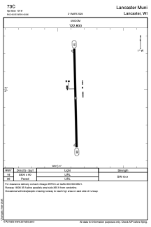
ADC chart of 73C
 Satellite view of 73C
Satellite view of 73C
Sorry, we have no imagery here.
Sorry, we have no imagery here.
Sorry, we have no imagery here.
Sorry, we have no imagery here.
Sorry, we have no imagery here.


73C - Lancaster Muni
Located in Lancaster, United States
ICAO - 73C, IATA -
Data provided by AirmateGeneral information
Coordinates: N42°46'57" W90°40'52"
Elevation is 1016 feet MSL.
Magnetic variation is 01° East View others Airports in Wisconsin
Operational data
Special qualification required
Current time UTC:
Current local time:
Weather at : KPVB - Platteville Muni ( 22 km )
METAR: KPVB 190735Z AUTO 08012KT 10SM CLR 07/04 A3004 RMK AO1 T00720036
Communications frequencies: [VIEW]
Runways:
| RWY identifier | QFU | Length (ft) | Width (ft) | Surface | LDA (ft) |
| 18 | 179° | 3300 | 60 | ASPH | |
| 36 | 359° | 3300 | 60 | ASPH |
Airport contact information
Address: Lancaster United States
Satellite view of 73C
Sorry, we have no imagery here.
Sorry, we have no imagery here.
Sorry, we have no imagery here.
Sorry, we have no imagery here.
Sorry, we have no imagery here.