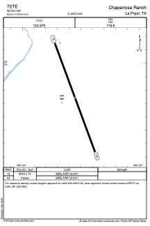
ADC chart of 72TE
 Satellite view of 72TE
Satellite view of 72TE
Sorry, we have no imagery here.
Sorry, we have no imagery here.
Sorry, we have no imagery here.
Sorry, we have no imagery here.
Sorry, we have no imagery here.
Sorry, we have no imagery here.


72TE - Chaparrosa Ranch
Located in La Pryor, United States
ICAO - 72TE, IATA -
Data provided by AirmateGeneral information
Coordinates: N28°52'45" W99°59'33"
Elevation is 682 feet MSL.
Magnetic variation is 05° East View others Airports in Texas
Operational data
Special qualification required
Current time UTC:
Current local time:
Weather at : KCZT - Dimmit County ( 43 km )
METAR: KCZT 021215Z AUTO 00000KT 10SM 22/22 A2949 RMK AO2
Communications frequencies: [VIEW]
Runways:
| RWY identifier | QFU | Length (ft) | Width (ft) | Surface | LDA (ft) |
| 15 | 159° | 5200 | 75 | ASPH | |
| 33 | 339° | 5200 | 75 | ASPH |
Airport contact information
Address: La Pryor United States
Satellite view of 72TE
Sorry, we have no imagery here.
Sorry, we have no imagery here.
Sorry, we have no imagery here.
Sorry, we have no imagery here.
Sorry, we have no imagery here.
Sorry, we have no imagery here.