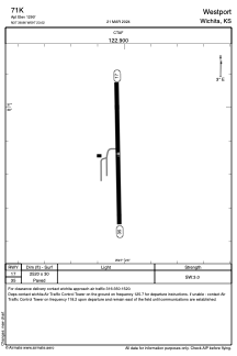
ADC chart of 71K
 Satellite view of 71K
Satellite view of 71K
Sorry, we have no imagery here.
Sorry, we have no imagery here.
Sorry, we have no imagery here.
Sorry, we have no imagery here.
Sorry, we have no imagery here.
Sorry, we have no imagery here.


71K - Westport
Located in Wichita, United States
ICAO - 71K, IATA -
Data provided by AirmateGeneral information
Coordinates: N37°38'52" W97°23'1"
Elevation is 1290 feet MSL.
Magnetic variation is 07° East View others Airports in Kansas
Operational data
Special qualification required
Current time UTC:
Current local time:
Weather at : KICT - Wichita Dwight D Eisenhower Ntl ( 4 km )
METAR: KICT 101653Z 01017G23KT 10SM CLR 22/02 A3028 RMK AO2 SLP247 T02170017
TAF: KICT 101731Z 1018/1118 34018G27KT P6SM SKC FM110000 34012KT P6SM SKC FM110300 35005KT P6SM SKC
Communications frequencies: [VIEW]
Runways:
| RWY identifier | QFU | Length (ft) | Width (ft) | Surface | LDA (ft) |
| 17 | 0° | 2520 | 30 | ASPH | |
| 35 | 0° | 2520 | 30 | ASPH |
Airport contact information
Address: Wichita United States
Satellite view of 71K
Sorry, we have no imagery here.
Sorry, we have no imagery here.
Sorry, we have no imagery here.
Sorry, we have no imagery here.
Sorry, we have no imagery here.
Sorry, we have no imagery here.