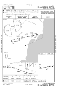
IAC chart of 6D9
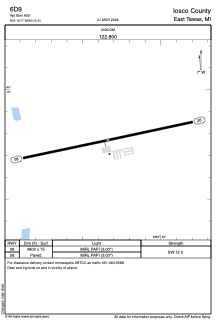
 ADC chart of 6D9
 Satellite view of 6D9
ADC chart of 6D9
Satellite view of 6D9
Sorry, we have no imagery here.
Sorry, we have no imagery here.
Sorry, we have no imagery here.
Sorry, we have no imagery here.
Sorry, we have no imagery here.
Sorry, we have no imagery here.


6D9 - Iosco County
Located in East Tawas, United States
ICAO - 6D9, IATA -
Data provided by AirmateGeneral information
Coordinates: N44°18'46" W83°25'20"
Elevation is 605 feet MSL.
Magnetic variation is -08° East View others Airports in Michigan
Operational data
Special qualification required
Current time UTC:
Current local time:
Weather at : KOSC - Oscoda/Wurtsmith ( 16 km )
METAR: KOSC 021855Z AUTO 19010G17KT 10SM OVC006 01/M00 A2987 RMK AO2 P0001
Communications frequencies: [VIEW]
Runways:
| RWY identifier | QFU | Length (ft) | Width (ft) | Surface | LDA (ft) |
| 08 | 78° | 4802 | 75 | ASPH | |
| 26 | 258° | 4802 | 75 | ASPH |
Airport contact information
Address: East Tawas United States
Satellite view of 6D9
Sorry, we have no imagery here.
Sorry, we have no imagery here.
Sorry, we have no imagery here.
Sorry, we have no imagery here.
Sorry, we have no imagery here.
Sorry, we have no imagery here.