ADC chart of 6B4
 Satellite view of 6B4
Satellite view of 6B4
Sorry, we have no imagery here.
Sorry, we have no imagery here.
Sorry, we have no imagery here.
Sorry, we have no imagery here.
Sorry, we have no imagery here.


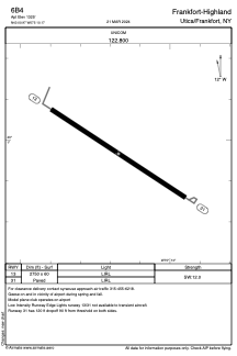
6B4 - Frankfort-Highland
Located in Utica/Frankfort, United States
ICAO - 6B4, IATA -
Data provided by AirmateGeneral information
Coordinates: N43°0'58" W75°10'10"
Elevation is 1325 feet MSL.
Magnetic variation is -13° East View others Airports in New York
Operational data
Special qualification required
Current time UTC:
Current local time:
Weather at : KRME - Griffiss Intl ( 31 km )
METAR: KRME 061553Z 29013KT 10SM BKN019 OVC024 03/00 A2994 RMK AO2 SLP140 T00330000
TAF: KRME 061120Z 0612/0712 28007G13KT P6SM OVC012 TEMPO 0615/0617 BKN025 FM061700 29007G15KT P6SM BKN040 FM070100 29004KT P6SM BKN170
Communications frequencies: [VIEW]
Runways:
| RWY identifier | QFU | Length (ft) | Width (ft) | Surface | LDA (ft) |
| 13 | 123° | 2750 | 60 | ASPH | |
| 31 | 303° | 2750 | 60 | ASPH |
Airport contact information
Address: Utica/Frankfort United States
Satellite view of 6B4
Sorry, we have no imagery here.
Sorry, we have no imagery here.
Sorry, we have no imagery here.
Sorry, we have no imagery here.
Sorry, we have no imagery here.