IAC chart of 6A4
ADC chart of 6A4
Satellite view of 6A4
Sorry, we have no imagery here.
To navigate, press the arrow keys.
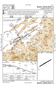
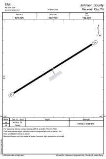
6A4 - Johnson County
Located in Mountain City, United States
ICAO - 6A4, IATA -
Data provided by
Airmate
General information
Coordinates:
N36°25'4" W81°49'30"
Elevation is
2241 feet MSL.
Magnetic variation is
-07° East
Add your vote
Valid your vote
View others
Airports in
Tennessee
Operational data
Special qualification required
Current time UTC:
Current local time:
View NOTAMs / SUP AIP / TFR affecting this airport
[VIEW]
Communications frequencies:
[VIEW]
Runways:
RWY identifier
QFU
Length
(ft)
Width
(ft)
Surface
LDA
(ft)
07
58°
4498
75
ASPH
25
238°
4498
75
ASPH
Airport contact information
Address:
Mountain City United States
Satellite view of 6A4
Sorry, we have no imagery here.
To navigate, press the arrow keys.
<<
BESbswy
BESbswy