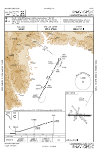
IAC chart of 69V
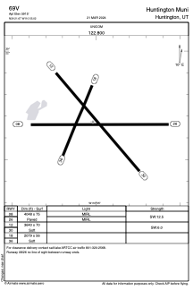
 ADC chart of 69V
 Satellite view of 69V
ADC chart of 69V
Satellite view of 69V
Sorry, we have no imagery here.
Sorry, we have no imagery here.
Sorry, we have no imagery here.
Sorry, we have no imagery here.
Sorry, we have no imagery here.
Sorry, we have no imagery here.


69V - Huntington Muni
Located in Huntington, United States
ICAO - 69V, IATA -
Data provided by AirmateGeneral information
Coordinates: N39°21'40" W110°55'1"
Elevation is 5915 feet MSL.
Magnetic variation is 14° East View others Airports in Utah
Operational data
Special qualification required
Current time UTC:
Current local time:
Weather at : KPUC - Carbon County Rgnl/Buck Davis Fld ( 31 km )
METAR: KPUC 011253Z AUTO 06006KT 10SM CLR 01/M04 A2957 RMK AO2 SLP005 T00061039
Communications frequencies: [VIEW]
Runways:
| RWY identifier | QFU | Length (ft) | Width (ft) | Surface | LDA (ft) |
| 08 | 90° | 4048 | 75 | ASPH | |
| 26 | 270° | 4048 | 75 | ASPH | |
| 12 | 140° | 3640 | 70 | EARTH | |
| 30 | 320° | 3640 | 70 | EARTH | |
| 18 | 203° | 2079 | 56 | EARTH | |
| 36 | 23° | 2079 | 56 | EARTH |
Airport contact information
Address: Huntington United States
Satellite view of 69V
Sorry, we have no imagery here.
Sorry, we have no imagery here.
Sorry, we have no imagery here.
Sorry, we have no imagery here.
Sorry, we have no imagery here.
Sorry, we have no imagery here.