ADC chart of 68F
 Satellite view of 68F
Satellite view of 68F
Sorry, we have no imagery here.
Sorry, we have no imagery here.
Sorry, we have no imagery here.
Sorry, we have no imagery here.
Sorry, we have no imagery here.
Sorry, we have no imagery here.


68F - Teague Muni
Located in Teague, United States
ICAO - 68F, IATA -
Data provided by AirmateGeneral information
Coordinates: N31°39'42" W96°18'38"
Elevation is 525 feet MSL.
Magnetic variation is 06° East View others Airports in Texas
Operational data
Special qualification required
Current time UTC:
Current local time:
Weather at : KLXY - Mexia-Limestone County ( 19 km )
METAR: KLXY 020555Z AUTO 17017G26KT 7SM OVC022 23/20 A2958 RMK AO2 T02320195 10250 20231 402550141 TSNO
Communications frequencies: [VIEW]
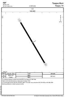
Runways:
| RWY identifier | QFU | Length (ft) | Width (ft) | Surface | LDA (ft) |
| 15 | 149° | 3300 | 50 | ASPH | |
| 33 | 329° | 3300 | 50 | ASPH |
Airport contact information
Address: Teague United States
Satellite view of 68F
Sorry, we have no imagery here.
Sorry, we have no imagery here.
Sorry, we have no imagery here.
Sorry, we have no imagery here.
Sorry, we have no imagery here.
Sorry, we have no imagery here.