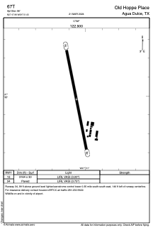
ADC chart of 67T
 Satellite view of 67T
Satellite view of 67T
Sorry, we have no imagery here.
Sorry, we have no imagery here.
Sorry, we have no imagery here.
Sorry, we have no imagery here.
Sorry, we have no imagery here.
Sorry, we have no imagery here.


67T - Old Hoppe Place
Located in Agua Dulce, United States
ICAO - 67T, IATA -
Data provided by AirmateGeneral information
Coordinates: N27°47'59" W97°51'3"
Elevation is 96 feet MSL.
Magnetic variation is 06° East View others Airports in Texas
Operational data
Special qualification required
Current time UTC:
Current local time:
Weather at : KRBO - Nueces County ( 16 km )
METAR: KRBO 020735Z AUTO 16019G23KT 7SM BKN014 25/23 A2955 RMK AO2 T02450230
Communications frequencies: [VIEW]
Runways:
| RWY identifier | QFU | Length (ft) | Width (ft) | Surface | LDA (ft) |
| 16 | 0° | 3164 | 30 | CONC | |
| 34 | 0° | 3164 | 30 | CONC |
Airport contact information
Address: Agua Dulce United States
Satellite view of 67T
Sorry, we have no imagery here.
Sorry, we have no imagery here.
Sorry, we have no imagery here.
Sorry, we have no imagery here.
Sorry, we have no imagery here.
Sorry, we have no imagery here.