ADC chart of 66IL
 Satellite view of 66IL
Satellite view of 66IL
Sorry, we have no imagery here.
Sorry, we have no imagery here.
Sorry, we have no imagery here.
Sorry, we have no imagery here.
Sorry, we have no imagery here.


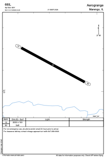
66IL - Aerogrange
Located in Marengo, United States
ICAO - 66IL, IATA -
Data provided by AirmateGeneral information
Coordinates: N42°16'7" W88°34'17"
Elevation is 824 feet MSL.
Magnetic variation is -00° East View others Airports in Illinois
Operational data
Special qualification required
Current time UTC:
Current local time:
Weather at : KDKB - De Kalb Taylor Muni ( 39 km )
METAR: KDKB 071435Z AUTO 36018G24KT 10SM CLR 05/M02 A2987 RMK AO2 T00491017
Communications frequencies: [VIEW]
Runways:
| RWY identifier | QFU | Length (ft) | Width (ft) | Surface | LDA (ft) |
| 12 | 118° | 2050 | 100 | GRASS | |
| 30 | 298° | 2050 | 100 | GRASS |
Airport contact information
Address: Marengo United States
Satellite view of 66IL
Sorry, we have no imagery here.
Sorry, we have no imagery here.
Sorry, we have no imagery here.
Sorry, we have no imagery here.
Sorry, we have no imagery here.