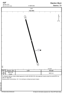
ADC chart of 63F
 Satellite view of 63F
Satellite view of 63F
Sorry, we have no imagery here.
Sorry, we have no imagery here.
Sorry, we have no imagery here.
Sorry, we have no imagery here.
Sorry, we have no imagery here.
Sorry, we have no imagery here.


63F - Stanton Muni
Located in Stanton, United States
ICAO - 63F, IATA -
Data provided by AirmateGeneral information
Coordinates: N32°10'25" W101°49'21"
Elevation is 2731 feet MSL.
Magnetic variation is 09° East View others Airports in Texas
Operational data
Special qualification required
Current time UTC:
Current local time:
Weather at : KBPG - Big Spring/Mc Mahon-Wrinkle ( 29 km )
METAR: KBPG 020435Z AUTO 17018KT 10SM CLR 25/13 A2945 RMK AO2 T02470132
Communications frequencies: [VIEW]
Runways:
| RWY identifier | QFU | Length (ft) | Width (ft) | Surface | LDA (ft) |
| 16 | 165° | 4240 | 60 | ASPH | |
| 34 | 345° | 4240 | 60 | ASPH |
Airport contact information
Address: Stanton United States
Satellite view of 63F
Sorry, we have no imagery here.
Sorry, we have no imagery here.
Sorry, we have no imagery here.
Sorry, we have no imagery here.
Sorry, we have no imagery here.
Sorry, we have no imagery here.