ADC chart of 62C
 Satellite view of 62C
Satellite view of 62C
Sorry, we have no imagery here.
Sorry, we have no imagery here.
Sorry, we have no imagery here.
Sorry, we have no imagery here.
Sorry, we have no imagery here.
Sorry, we have no imagery here.


62C - Cindy Guntly Meml
Located in Franksville, United States
ICAO - 62C, IATA -
Data provided by AirmateGeneral information
Coordinates: N42°48'41" W88°5'39"
Elevation is 784 feet MSL.
Magnetic variation is -01° East View others Airports in Wisconsin
Operational data
Special qualification required
Current time UTC:
Current local time:
Weather at : KBUU - Burlington Muni ( 22 km )
METAR: KBUU 220855Z AUTO 33006KT 10SM BKN045 OVC050 08/07 A2989 RMK AO2 T00760070 PWINO
Communications frequencies: [VIEW]
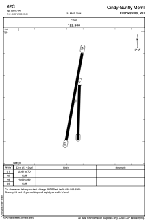
Runways:
| RWY identifier | QFU | Length (ft) | Width (ft) | Surface | LDA (ft) |
| 01 | 10° | 2381 | 70 | GRASS | |
| 19 | 190° | 2381 | 70 | GRASS | |
| 18 | 182° | 1239 | 80 | GRASS | |
| 36 | 2° | 1239 | 80 | GRASS |
Airport contact information
Address: Franksville United States
Satellite view of 62C
Sorry, we have no imagery here.
Sorry, we have no imagery here.
Sorry, we have no imagery here.
Sorry, we have no imagery here.
Sorry, we have no imagery here.
Sorry, we have no imagery here.