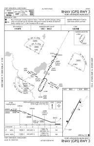
IAC chart of 61C
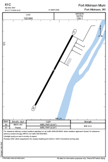
 ADC chart of 61C
 Satellite view of 61C
ADC chart of 61C
Satellite view of 61C
Sorry, we have no imagery here.
Sorry, we have no imagery here.
Sorry, we have no imagery here.
Sorry, we have no imagery here.
Sorry, we have no imagery here.
Sorry, we have no imagery here.


61C - Fort Atkinson Muni
Located in Fort Atkinson, United States
ICAO - 61C, IATA -
Data provided by AirmateGeneral information
Coordinates: N42°57'48" W88°49'3"
Elevation is 800 feet MSL.
Magnetic variation is -02° East View others Airports in Wisconsin
Operational data
Special qualification required
Current time UTC:
Current local time:
Weather at : KRYV - Watertown Muni ( 24 km )
METAR: KRYV 202135Z AUTO 09015G22KT 5SM -RA OVC007 07/07 A2973 RMK AO2 P0005 T00700067
Communications frequencies: [VIEW]
Runways:
| RWY identifier | QFU | Length (ft) | Width (ft) | Surface | LDA (ft) |
| 03 | 28° | 3800 | 60 | ASPH | |
| 21 | 208° | 3800 | 60 | ASPH |
Airport contact information
Address: Fort Atkinson United States
Satellite view of 61C
Sorry, we have no imagery here.
Sorry, we have no imagery here.
Sorry, we have no imagery here.
Sorry, we have no imagery here.
Sorry, we have no imagery here.
Sorry, we have no imagery here.