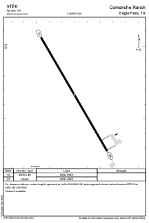
ADC chart of 5TE0
 Satellite view of 5TE0

Satellite view of 5TE0
Sorry, we have no imagery here.
Sorry, we have no imagery here.
Sorry, we have no imagery here.
Sorry, we have no imagery here.
Sorry, we have no imagery here.
Sorry, we have no imagery here.


5TE0 - Comanche Ranch
Located in Eagle Pass, United States
ICAO - 5TE0, IATA -
Data provided by AirmateGeneral information
Coordinates: N28°37'40" W100°9'42"
Elevation is 734 feet MSL.
Magnetic variation is 07° East View others Airports in Texas
Operational data
Special qualification required
Current time UTC:
Current local time:
Weather at : KCZT - Dimmit County ( 35 km )
METAR: KCZT 020335Z AUTO 15015G20KT 10SM 27/21 A2951 RMK AO2
Communications frequencies: [VIEW]
Runways:
| RWY identifier | QFU | Length (ft) | Width (ft) | Surface | LDA (ft) |
| 15 | 150° | 5500 | 80 | ASPH | |
| 33 | 330° | 5500 | 80 | ASPH |
Airport contact information
Address: Eagle Pass United States
Satellite view of 5TE0
Sorry, we have no imagery here.
Sorry, we have no imagery here.
Sorry, we have no imagery here.
Sorry, we have no imagery here.
Sorry, we have no imagery here.
Sorry, we have no imagery here.