ADC chart of 5N2
 Satellite view of 5N2
Satellite view of 5N2
Sorry, we have no imagery here.
Sorry, we have no imagery here.
Sorry, we have no imagery here.
Sorry, we have no imagery here.
Sorry, we have no imagery here.
Sorry, we have no imagery here.


5N2 - Prentice
Located in Prentice, United States
ICAO - 5N2, IATA -
Data provided by AirmateGeneral information
Coordinates: N45°32'18" W90°16'35"
Elevation is 1579 feet MSL.
Magnetic variation is 00° East View others Airports in Wisconsin
Operational data
Special qualification required
Current time UTC:
Current local time:
Weather at : KPBH - Price County ( 21 km )
METAR: KPBH 232115Z AUTO 34004KT 10SM OVC048 12/02 A3011 RMK AO2 T01200023
Communications frequencies: [VIEW]
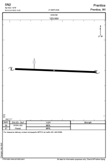
Runways:
| RWY identifier | QFU | Length (ft) | Width (ft) | Surface | LDA (ft) |
| 09 | 0° | 3134 | 60 | ASPH | |
| 27 | 0° | 3134 | 60 | ASPH |
Airport contact information
Address: Prentice United States
Satellite view of 5N2
Sorry, we have no imagery here.
Sorry, we have no imagery here.
Sorry, we have no imagery here.
Sorry, we have no imagery here.
Sorry, we have no imagery here.
Sorry, we have no imagery here.